How to Visit Thormanby Island, BC (2025 Guide)
Thormanby Island is just a short boat ride from BC’s Sunshine Coast near Sechelt. The water taxi lands you on one of the most impressive sandy beaches in the province. Even better, the main beach is a massive sandbar that is all that connects the north and south islands. You can pick between views of the Sunshine Coast stretching off into the horizon from the eastern side of the sandbar, or sprawling views of Texada Island and distant peaks of Vancouver Island silhouetted against the horizon on the west.
There are full time residents on both islands but the sandbar that connects them is a provincial park. It’s a perfect day trip with the option to camp overnight. Plan around the tides and bring all the supplies you need; there are no shops or water sources on the island.

Last updated October 14, 2025
Key Tips for Visiting Thormanby Island

- Bring Everything: There are no shops, restaurants, or fresh water. Pack food, water, and camping gear if staying overnight.
- Plan Around Tides: The walk to Vaucroft beach is only possible at low tide. But you will want to arrive on the island during high tide. At low tide the water taxi can’t get very close to shore and it can be a long walk through sinking sand with all your gear.
- Leave No Trace: It’s a sensitive ecosystem with limited human impact so far.
- Check The Weather: Winds and water conditions can change quickly, especially if you’re crossing in a small boat.
- Keep An Eye On The Water: Seals and orcas are commonly spotted not far from shore.
How to get to Thormanby Island
There are two private water taxi companies that do hourly departures to Thormanby Island. It's recommended to always book in advance as trips do book up in the summer months.
- Buccaneer Water Taxi based out of Buccaneer Marina is who we went with. The water taxi departs every hour on the hour and returns on the half hour. Fares depend on the number of passengers, ranging from $18–$60. A solo passenger would pay $60, a group of 4 would pay $22 per person, while groups of six or more pay $18 per person.
- Thormanby Water Taxi based out of Secret Cove Marina. They have the exact same schedule and rates as the company above.

We booked three days in advance by phone for our late-August visit and paid just $18 per person, each way. If you’re flexible on your arrival time, ask the receptionist if there is a time where some others have already booked on so you can get the lowest rate. The walk from the boat to the beach expands A LOT at lower tides. So if you’re going with lots of camping gear make sure to arrive at a higher tide.
Other ways to get to Thormanby Island:
- By Boat: If you happen to have your own boat, you can sail to Thormanby Island and anchor off shore from Buccaneer Bay.
- Kayak: Adventurous paddlers sometimes make the crossing from Secret Cove. It's not too long of a route, but currents and wind can be tricky and change quickly. This is only recommended for experienced paddlers on calm days.
Best Things To Do on Thormanby Island
1. Lounge on the Beaches
There are three beaches to choose from, but the standout is Buccaneer Bay West. Located within Buccaneer Provincial Park, it, and the east facing beach, are the only ones on the island with guaranteed public access. Vaucroft Beach is technically public too, but it’s only accessible at low tide; otherwise, you risk trespassing on private property owned by beachfront homes along the way.
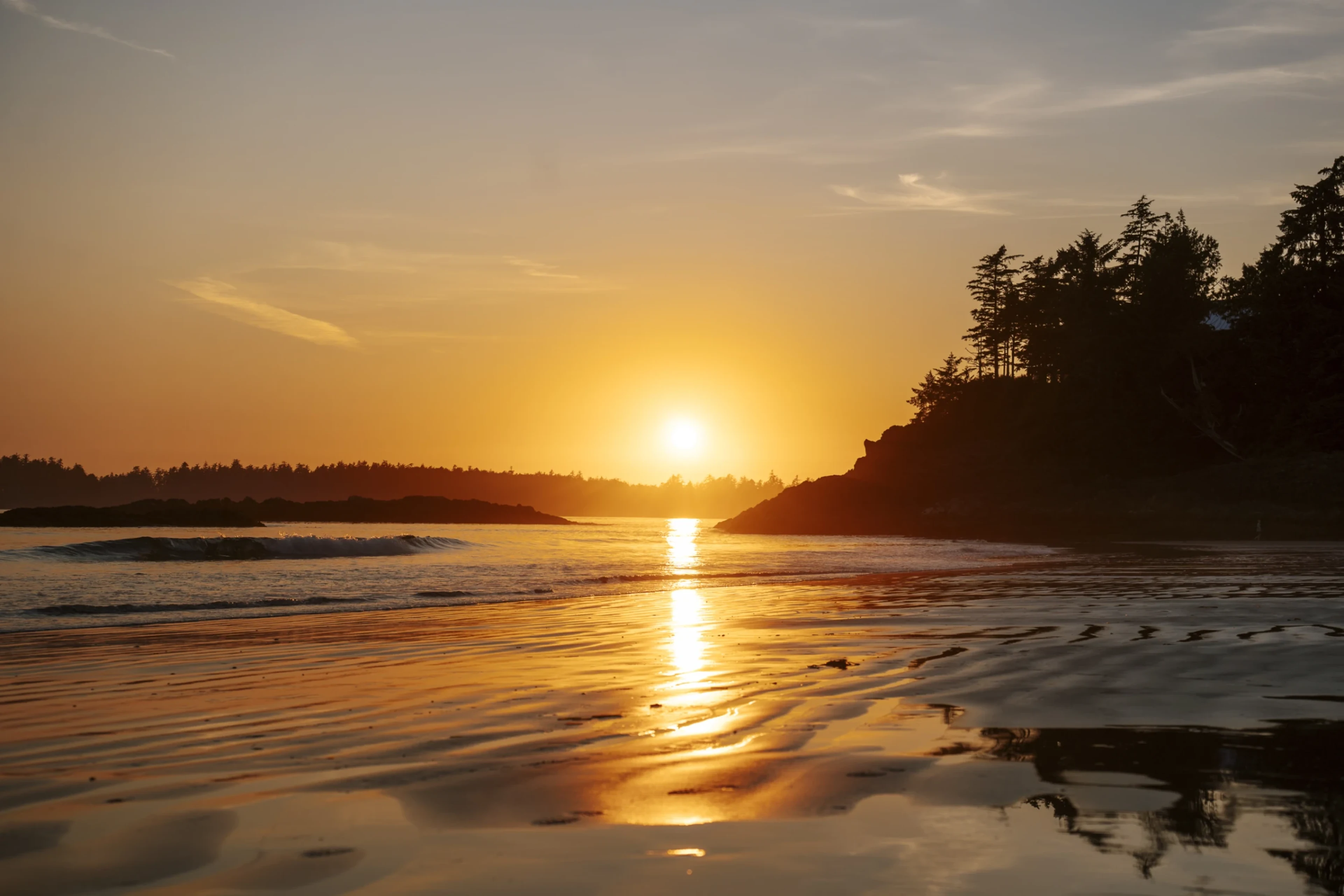
- Buccaneer Bay West: The western side is the day use side. Clear signage prohibits camping, smoking, and fires on this side. Great swimming beach. Best at high tide. This is also the sunset beach. Go down to the southern part of the beach and watch the sky turn orange as the sun dips behind the silhouette of Texada Island.
- Buccaneer Bay East: The eastern side is where the camping spots are. More boats dock near here so the western side is a bit better for swimming.
- Vaucroft Beach: This is a beautiful sandy beach that is massive at low tide and then disappears almost entirely at high tide. The water taxi makes a stop here, however it's typically for locals who live along the beach. At low tide you can walk the beach from Vaucroft Beach to Buccaneer Bay.


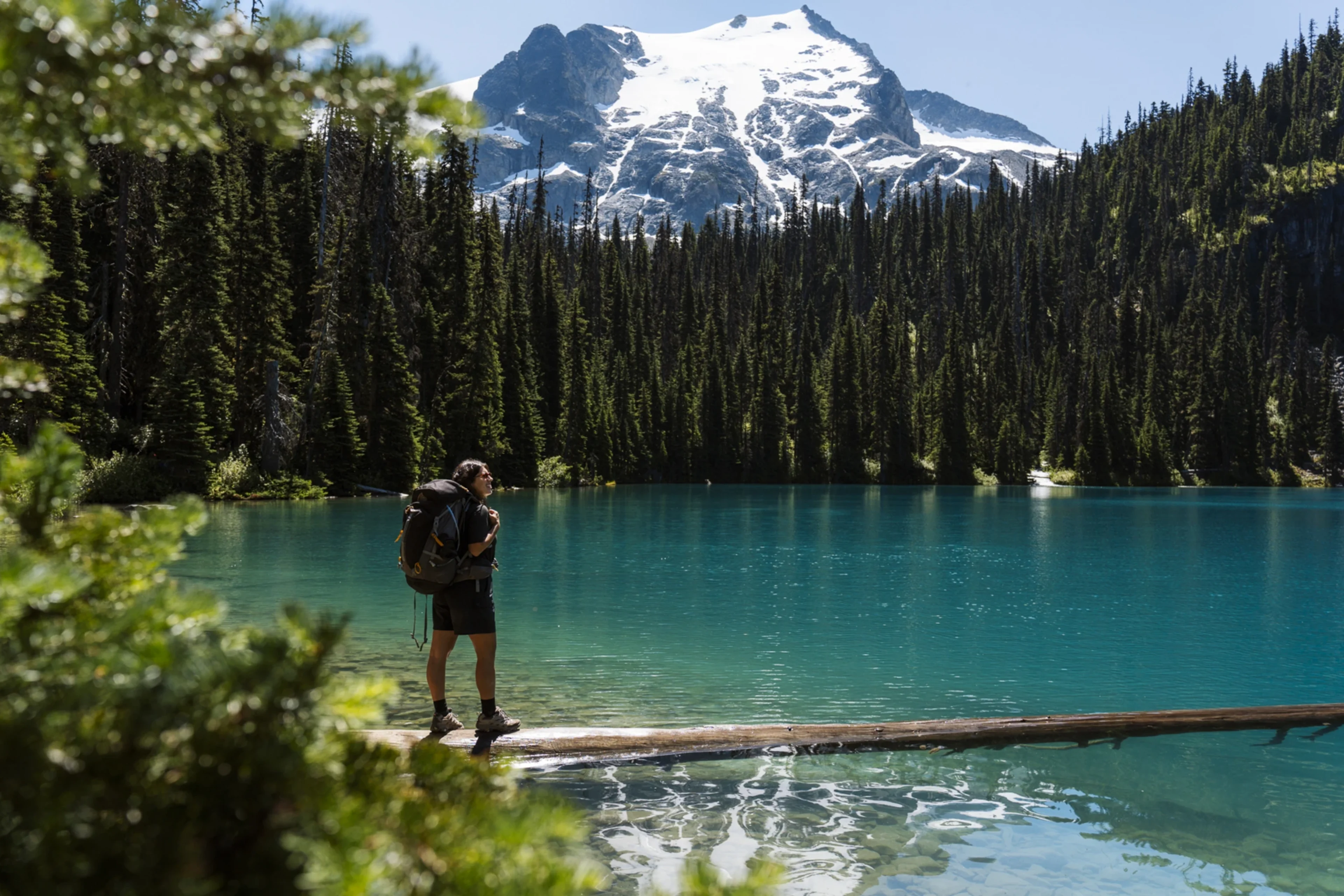
2. Go for a Hike
The trail on the North island is basically just a road used by the locals. The southern end of South Thormanby is part of Simson Provincial Park and you will find more interesting trails there. If you’re visiting at low tide you can also walk around both islands on the sand. We recommend walking between Buccaneer Bay and Vaucroft Beach at low tide if you’re looking to get some steps in.
3. Camp Overnight
Buccaneer Bay Park has five designated campsites, along with two pit toilets and two large bear caches. Camping here is free, and registration is done via the clipboard and form posted near the pit toilets. The sites are first-come, first-served: on weekdays you’ll likely find a spot without issue, but on weekends and holidays they can fill up early. We arrived on a Sunday just as one group was leaving, and throughout the afternoon we saw sites turn over quickly as campers packed up and new arrivals moved in. Since there are no official check-in or check-out times, this can cause some confusion -- so it’s a good idea to check the registration form by the pit toilets to see which sites are about due become available that day.
Most of the year camp fires are prohibited due to wildfire risk. Check the signage around camp if you’re not sure on the fire ban status.


4. Explore the Tidal Sandbar
The sandbar is littered with drift wood of all shapes and sizes and there are dozens of little structures constructed using just the driftwood over the years. There are trails through the sand you can follow or you can hop between drift wood logs. Be careful to avoid the areas that are fenced off. Some of the land is private property, and some sections are delicate ecosystems that the park is actively rehabilitating.

5. Paddle or Swim
The sheltered bays are perfect for kayaking, paddleboarding, or a dip in the summer. But be aware, ocean water in BC is always brisk, even in August.

Where is Thormanby Island?

Thormanby is an island in the Strait of Georgia. It's not far from the coast around Smugglers Cove. There are actually two islands: North Thormanby and South Thormanby. They are separated by a tidal sandbar that grows and shrinks as the tides ebb and flow.
Where to Stay Nearby
If you don’t want to camp, your best bet is to stay on the mainland and boat over for the day. Options include:
- Secret Cove: Cabins and B&Bs close to the marina.
- Halfmoon Bay: Cozy lodges tucked into the forest.
- Sechelt: A bigger hub with hotels, restaurants, and more services.
You can browse all the major hotels here and compare their prices:
What to Eat

On the island itself you can only eat what you bring. For before or after your trip:
- Secret Cove Marina Store: Snacks, drinks, and some basics.
- Halfmoon Bay Café: Great for coffee and a hearty breakfast before heading out.
- Sechelt: Plenty of options, from fish and chips to vegan cafés if you want a proper meal after a beach day.
When to Visit Thormanby Island

Summer is best for beach weather and calm seas, though it can get busier on weekends with local boaters. Spring and Autumn are quieter, with more wildlife spotting opportunities. Winter is stormy and less predictable. Beautiful, but not ideal for casual trips. The camping areas close soon after the end of summer.
A Bit of History

Before boaters and campers started to visit Thormanby, these islands were part of the traditional territory of the shíshálh (Sechelt) Nation, who fished, gathered shellfish, and moved seasonally through the area. Middens (ancient shell deposits) and other archaeological sites still exist along the shoreline, though most are unmarked.
In the late 1800s, settlers began logging parts of the islands and small homesteads appeared. The most visible reminder today is within Simson Provincial Park on South Thormanby, where you can still find the ruins of an old farmhouse, apple orchards, and meadows that were once grazed by livestock.
The name Thormanby itself comes from a British racehorse that won the Epsom Derby in 1860. The islands were named shortly after by Captain George Richards of the Royal Navy.
Today, the north island has a small community of off-grid cabins and 2 provincial parks.